We may never be able to predict earthquakes – but we can already know enough to be prepared


Hadi Ghasemi, Geoscience Australia and Phil R. Cummins, Australian National UniversityYesterday’s earthquake in eastern Victoria shook the ground for hundreds of kilometres around and damaged buildings as far away as Melbourne – and took many people by surprise.

While Australia doesn’t compare with seismic hotspots like New Zealand and Japan, relatively small quakes are expected, with Geoscience Australia’s quake tracker listing more than a dozen in the past week alone.


Read more:
Melbourne earthquake: what exactly happened, and what’s the best way to stay safe from aftershocks?


Even though earthquakes happen all the time, we still can’t predict when the next one will strike, or where, or how big it will be. Unfortunately, we may never be able to make that kind of prediction.

But we can estimate the likelihood of future quakes – and often, that’s enough to make sure our cities are prepared to cope with them.

Why we can’t predict earthquakes

Earthquakes are caused by sudden slips or ruptures in the rock beneath our feet, driven by the movement of the enormous tectonic plates that make up the Earth’s crust.

The exact timing and location of one of these slips are impossible for us to know in advance. Nobody has ever found a reliable and repeatable indicator that a quake is about to happen. We would need a highly detailed model of all the rock everywhere inside the Earth and an understanding of how it responds to tectonic stress to even stand a chance of predicting an earthquake.

However, suppose we understand the large forces driving the tectonic plates and the current level of earthquake activity, and we also study where faults have ruptured in the past. In that case, we can estimate the likelihood that different types of earthquakes might occur in the future.

What we can predict

To calculate the probability of future earthquakes, we look at the seismic activity measured since the development of seismometers about 100 years ago and knowledge of earlier earthquakes from the historical record, and combine these with information about the faults in the Earth’s crust where quakes can occur.

Australia has relatively little seismic activity, but we know there are hundreds of small faults beneath the Australian landmass. These are places where pressure created by the movement of tectonic plates can cause fault rupture or “slip”, which we experience as earthquakes that generate seismic waves and ground shaking.
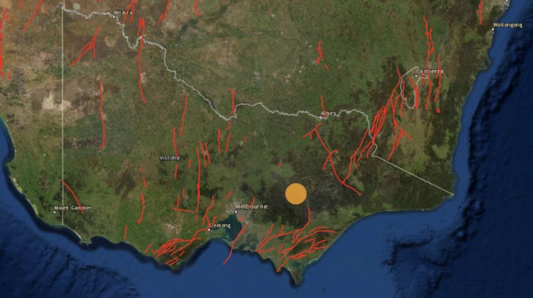
Red lines show faults beneath Victoria detected by scientists. The orange circle shows the location of yesterday’s quake.
Geoscience Australia

When we discover a fault, from studying earthquakes or looking at aerial imagery, we often send out teams of geologists to dig trenches across the fault to find traces of past, often prehistoric, earthquake rupture. Depending on the type of signature past earthquakes have left in the soil profile, we can estimate the age and extent of fault movement and develop a history of earthquake activity extending hundreds or often thousands of years into the past.

Identifying prehistoric events is important because the time between large earthquakes on major faults may be longer than the instrumental or even historical record. Without knowledge of prehistoric events, we would have to rely exclusively on the relatively short history of instrumentally recorded earthquakes.

This may cause us to miss the big earthquakes that happen very rarely. We know that longer faults, for example, can usually produce bigger quakes – so if even if we haven’t seen a big quake at a long fault, we know it may be possible in future.


Read more:
The earthquake that rattled Melbourne was among Australia’s biggest in half a century, but rock records reveal far mightier ones


By combining knowledge of the large earthquake history of nearby faults, and the level of activity of random, smaller earthquakes that may not rupture major faults but occur often enough to be estimated from the instrumental record, we can make a computer model of the likelihood of earthquake occurrence.

For this earthquake occurrence model to be helpful in estimating hazard, we also need to calculate the strength of ground motion generated by each earthquake. This depends strongly on the depth, location, and size of each earthquake.

The ground motion also depends on the properties of rock in the Earth’s crust through which the seismic waves pass, with some rocks absorbing more energy than others. It also depends on the local geology and soil profile near the site of interest, with softer soil leading to stronger ground motion.

Mapping hazards

At Geoscience Australia, we have mapped some of these probabilities in the National Seismic Hazard Assessment. For everywhere in Australia, this map shows the ground motions that may be exceeded over the next 50 years, at certain levels of probability.
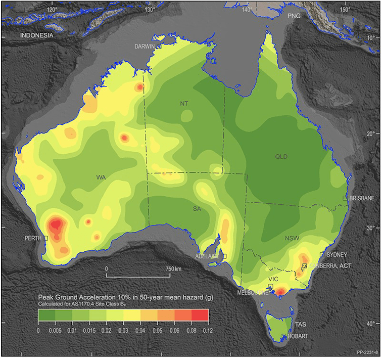
National Seismic Hazard Assessment of Australia map.
Geoscience Australia, CC BY-NC

This ground motion, usually expressed in terms of a fraction of the acceleration of gravity at the Earth’s surface, is what we call the seismic hazard. Its potential to damage things we value – buildings, for example, or human lives, is what we call “risk”.

From the “risk” point of view, we may not necessarily care if the hazard is high in a place where there are no people, for example, but we may be very concerned if the hazard is high in a big city.

Yesterday’s earthquake is a good example of this: a magnitude 5.9 earthquake in country Victoria is an exciting novelty for most, but the same earthquake occurring in Melbourne would cause huge problems.

Building codes use hazard maps like this to specify how much shaking buildings in an area need to withstand to keep the risk at an acceptable level. Engineers then make sure their buildings are constructed so they won’t fall when they experience the level of ground shaking forecast in the hazard map.


Read more:
Earthquakes don’t kill people; buildings do. And those lovely decorative bits are the first to fall


However, until the 1989 Newcastle earthquake, no one realised the Australian building code needed to account for earthquake hazard. Many buildings built before this may be vulnerable even to the level of ground shaking forecast by the hazard map.

An earthquake of magnitude 5.9, if it occurs as far from Melbourne as yesterday’s earthquake did, shouldn’t cause significant damage to buildings that follow the current building code. The fact that it did likely means some buildings are built to a lower standard, and indeed we can see from news photos that many of the damaged buildings look like they were built before 1989.

Insurance companies also use hazard maps to determine the likelihood of damaging earthquakes and set their premiums accordingly.

So, while we can’t tell you where the next earthquake will strike or how big it will be, we can quantify the likelihood of ground motion intensity at the location of interest to make sure we’re all ready for it.The Conversation

Hadi Ghasemi, Senior Seismologist, Geoscience Australia and Phil R. Cummins, Professor, Australian National University

This article is republished from The Conversation under a Creative Commons license. Read the original article.

Melbourne earthquake: what exactly happened, and what’s the best way to stay safe from aftershocks?


James Ross/AAP

Mark Quigley, The University of MelbourneA magnitude 5.8 earthquake has struck about 115 kilometres east of Melbourne in Victoria, causing damage to buildings and forcing residents to evacuate across the city. The quake, which started near Woods Point at a depth of 12km, was also felt in Sydney, Canberra, Adelaide and even as far as Launceston, Tasmania.

I and the co-author of this article, Dee Ninis, work as earthquake scientists at the Seismology Research Centre. Researching earthquakes is our life’s work. Here’s what you need to know to understand why today’s earthquake happened, and the geological conditions that triggered it.

Where was it exactly?

On-ground sensors distributed by the Seismology Research Centre have confirmed the earthquake was of a 5.8 magnitude, with an epicentre about 60km south-east of Mansfield in Victoria. The preliminary focal mechanism of this earthquake is strike-slip, meaning the rocks likely slid past each other laterally on what is probably an east-west oriented fault.

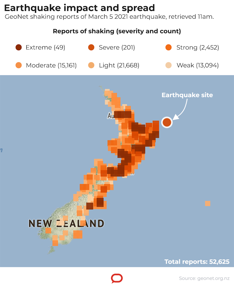
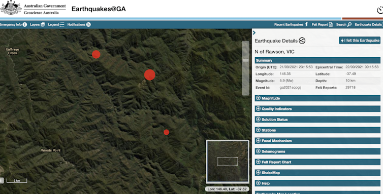
The earthquake was felt across the region at around 9.15am today. Geoscience Australia had received 32,409 felt reports as of when this article was published.
Screenshot/Geoscience Australia

Australia experiences fewer earthquakes than plate boundary regions, such as New Zealand. Many of Australia’s suspected neotectonic faults (faults which have hosted earthquakes in recent geological times) have not been thoroughly investigated, commonly due to lack of funding and resources for earthquake research.

However, earthquakes basically happen for the same reason in Australia as they do in New Zealand: there is a buildup of elastic strain energy in the crust, which eventually needs to be released. And most of this energy release occurs due to the rupture of weak zones in the crust, called faults.

Geoscience Australia hosts a database of what we think might be active faults across Australia, but few of these faults have been studied on the ground.

Most of the neotectonic faults near today’s earthquake were identified from remote elevation data — and this alone doesn’t reveal information such as when, how big and how often previous earthquakes on these faults occurred.

What we look for here is displacement at Earth’s surface, formed by movement during previous quakes. Such displacement is only caused by moderate to large earthquakes relatively close to the surface.

If it’s deep enough, it’s entirely possible for a quake to happen at a fault that never ruptures the surface — so we can’t see evidence for it. At a magnitude of 5.8 and a depth of 12km, we don’t expect today’s event to have an associated surface rupture, although it is remotely possible.

The Conversation’s readers sent in their accounts of the earthquake, which was felt across Melbourne’s suburbs.
The Conversation

Is this an unusual event?

While some early reports suggested today’s earthquake was the “largest on-land earthquake in Australia since 1997”, this isn’t the case. Australia has an earthquake of magnitude 6 or higher every six to ten years, on average. That’s based on an instrumental record going back about 150 years.

The 2016 Petermann Ranges earthquake in the Northern Territory was a magnitude 6.1 quake. And while Australia is not a tectonic plate boundary, it is still quite seismically active.

This morning’s earthquake was the largest onshore quake ever recorded in Victoria. Other recent earthquakes include two magnitude 5 quakes: one in 1996 near Mt Baw Baw, and one in 2012 near Moe.

But just because we haven’t seen such a high-magnitude earthquake in our time doesn’t mean they don’t happen. For instance, there is geological evidence for a possible magnitude 7 earthquake occurring sometime between 70,000 and 25,000 years ago, on the Cadell Fault near the Victorian town of Echuca.


Read more:
The earthquake that rattled Melbourne was among Australia’s biggest in half a century, but rock records reveal far mightier ones


Earthquakes are more intense and frequent in plate boundary regions. The Pacific plate boundary, which passes directly through New Zealand’s South Island, lies to Australia’s east.

But despite this — and although the tectonic deformation rates across Australia are lower than the deformation rates at plate boundary regions — Australia has seen earthquakes in places you wouldn’t expect (unless you’re an earthquake scientist).

For instance, the Tennant Creek earthquake sequence in 1988 saw three separate shocks erupt within 12 hours, with magnitudes of 6.2, 6.3 and 6.6 (the main shock).

What about aftershocks?

Several aftershocks followed the main event this morning, some occurring within the hour. In an earthquake sequence, an “aftershock” is defined as an earthquake that’s smaller than and which follows the main shock. The strongest aftershocks come soon after the main event and slowly taper off.

We do expect the region around today’s earthquake epicentre to remain active, and we will probably have more felt events in the next few days. In fact, we would expect aftershocks to continue up to decades afterwards, although through time most of these will become too small to be felt (the Tennant Creek earthquake sequence of 1988 is still ongoing).

If, under unfortunate circumstances, we experience an even larger earthquake soon — then that will become the main event, and the quake from this morning will be designated a “foreshock”.

So we all have to stay alert. Even if the aftershocks aren’t as intense in magnitude, smaller quakes can still be incredibly damaging depending on their depth and location. In the 2011 Christchurch disaster, it was an aftershock of magnitude 6.3 which wreaked the most havoc, and led to many people’s deaths.

How to prepare?

In terms of personal safety, the best thing to do during an earthquake is drop to the ground, take cover and hold on. If you’re inside a house or other building, try to crawl under something sturdy to protect yourself, such as a solid table. This will help save you from anything that might fall.

If you experience a quake while you’re outside, make sure you’re as far away from buildings and other structures as possible, as these too can fall on you. You need to be in an open area. Victoria’s State Emergency Service has more recommendations on what to do, including:

  • staying away from glass, windows, outside doors and walls and anything that could fall such as lighting fixtures
  • not using a doorway unless you know it is strongly supported and is close to you
  • keeping in mind the electricity may go out, and sprinkler systems or fire alarms may turn on.

Finally, if you’re considering any activities that might put you at risk, such as roofing, gutter cleaning, and other activities that involve the use of ladders, it is prudent to reconsider whether these are essential in the short term.


Acknowledgment: this article was co-authored by Dee Ninis, who works as an earthquake geologist at ESS Earth Sciences’s Seismology Research Centre based in Richmond, Victoria.The Conversation

Mark Quigley, Associate Professor of Earthquake Science, The University of Melbourne

This article is republished from The Conversation under a Creative Commons license. Read the original article.
The earthquake that rattled Melbourne was among Australia’s biggest in half a century, but rock records reveal far mightier ones


Mark Quigley, The University of Melbourne and Januka Attanayake, The University of MelbourneAn earthquake that struck near Melbourne today is one of the largest in Australia since instrumental seismic records began. However, the geological record of ground-breaking fault ruptures tells us much larger earthquakes have occurred across the continent. Some of these earthquakes would have been witnessed by Australia’s Indigenous peoples.

Several quakes were felt near Melbourne today, the largest of which was recorded at a magnitude of 5.8. A magnitude 4.7 aftershock happened about 15 minutes after the main shock, which was at 9:15am local time. A typical aftershock sequence could go on for weeks to years. Aftershocks went on for about 40 days following the Thorpdale, Victoria earthquake of magnitude 5 in 2021.

In Australia we get magnitude 5.8-6.0 or greater earthquakes, on average, once every four to 20 years. The highest since instrumental records began in Australia was the magnitude 6.6 quake in the Western Australia town of Meckering in 1968.

Earthquakes are considered a low probability, high consequence hazard — the rate of earthquakes is low compared to our seismically active neighbours in New Zealand, PNG, and Indonesia, but we have vulnerable infrastructure such as unreinforced masonry buildings that present a risk.


Read more:
‘Like tearing a piece of cheese’: here’s why Darwin was rocked so hard by a distant quake


How this quake compares

There are some big quakes in our recent past.

There was a magnitude 5.3 quake in 2018 in Western Australia.

Near Uluru in 2016, there was the Petermann earthquake, which had a magnitude of 6.1.

The largest in the record since instrumental records began in Australia was in 1988; it was part of the Tennant Creek series of quakes in the Northern Territory, and that was magnitude 6.5.

Then there was the aforementioned one in 1968 in the WA town of Meckering; that was 6.6.

But the geological record tells us we have had earthquakes in Australia’s deeper past that were much, much larger — possibly up to magnitude 7.0 and beyond.

The energy released by a magnitude 7.0 quake is 32 times larger than the energy from a magnitude 6.0 quake.

For each one point up the scale, the amount of energy released is about 32 times greater.

Why are quakes of this strength not common in Australia?

Compared with places like New Zealand and Indonesia, large quakes are not common in Australia. That’s because Australia is in the middle of a tectonic plate so what we call the “strain rate” — the rate at which energy builds up due to plates pushing against each other — is slow.

Indonesia is on a plate boundary, so the strain rate — the rate at which the Earth is being deformed — is much higher. That energy is released mainly through earthquakes.

Even though Australia is in the middle of a plate, strain can nevertheless build up over time — and eventually needs to find release.

Australia is moving northwards as part of the Indo-Australian tectonic plate, which is colliding with the plate near PNG and Indonesia, and that is pushing back — building up strain. New Zealand is also imposing a force onto the Australian plate.

A quake like today’s would normally cause a lot of damage

A magnitude 5.8 earthquake is a big deal. If such a quake occurred directly under one of our major cities, we could expect billions of dollars of damage and fatalities.

In many parts of Australia, such as Melbourne, earthquakes are felt at greater distances than in countries like New Zealand, because our crust is stiffer. Seismic waves travel more efficiently through Australian crust.

In Melbourne, the soft sediment south of the CBD and in other areas likely caused the seismic waves to slow down but also amplify. The seismic waves get bigger and can cause more damage when they are in soft sediments.

The scenes of toppled brickwork reflect the seismic energy that has travelled quite effectively 130km from the source of the tremor (which is reported to be near Mansfield).

They have almost certainly been amplified by the soft sediments, and the direction of the waves may make certain buildings more vulnerable than others.

Crucially, Melbourne has many buildings that are highly vulnerable to quake shaking: buildings with big overhangs, buildings that are unreinforced, or those that have been weathering away for decades without repair.

The sort of shaking that wouldn’t cause damage in other locations is causing damage in places like Melbourne.


Read more:
10 years since the Darfield earthquake rocked New Zealand: what have we learned?


The Conversation


Mark Quigley, Associate Professor of Earthquake Science, The University of Melbourne and Januka Attanayake, Research Fellow, The University of Melbourne

This article is republished from The Conversation under a Creative Commons license. Read the original article.

Following 3 major quakes off New Zealand, questions remain about how they might be linked


Martin Gruenzweig/Oneworld Picture/Universal Images Group via Getty Images

Timothy Stern, Te Herenga Waka — Victoria University of Wellington

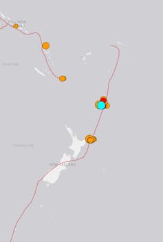
Map of earthquakes off New Zealand
The Tonga Kermadec subduction zone stretches between New Zealand and south of Samoa.
USGS, CC BY-SA

A sequence of three major offshore earthquakes, including a magnitude 8.1 quake near the Kermadec Islands, triggered tsunami warnings and evacuations along the east coast of New Zealand this morning.

By early afternoon, the National Emergency Management Agency (NEMA) lifted the evacuation order but stressed that people should stay off beaches and the shore.

All three earthquakes happened along the Tonga Kermadec subduction zone, where the Pacific tectonic plate dives under and then sinks beneath the Australian plate.

This subduction zone is the longest and deepest such system on Earth. It spans from just north of the East Cape, some 2600km to the north-east in an almost straight line to south of Samoa.

One of the questions seismologists around the world are now trying to answer is whether the three quakes were linked and the earlier ruptures triggered the magnitude 8.1 quake.

Potential links between ruptures

The Tonga Kermadec subduction zone terminates north-east of the East Cape, where it then becomes the Hikurangi subduction zone. The first 7.3 magnitude rupture struck at 2.27am, 174km off the east coast, where the Hikurangi and Tonga Kermadec systems merge.

The US Geological Survey recorded this event at a depth of 21km, not 95km deep as the first reports in New Zealand suggested. This quake had an unusual mechanism — an element of sideways movement known as strike-slip.


GeoNet.org.nz (static edited by The Conversation), CC BY-SA

The other two quakes were about 900km north, but just west of the Tonga-Kermadec trench and at depths of about 56km (for the 6.40am magnitude 7.4 event) and 20km (for the magnitude 8.1 quake at 8.28am). These later events had thrust, or compressive, mechanisms, in which one body of rock compresses against another, sliding up and over it during the earthquake.

This is what we might expect in a subduction zone where one tectonic plate is sliding under another and creating a collision, which in turn gives rise to compression.

As the Pacific plate starts to slide under the Australian plate, it starts off at a shallow angle and then turns along a curved trajectory to finally fall away at a very steep (60 degrees) angle. But when it’s at a shallow level, it is only dipping at say 10-20 degrees and creates a lot of friction with the overlying (Australian) plate. This is typically where these large earthquakes occur.

Triggering sequence

Magnitude 8 quakes in these subduction zone settings are not unusual. Indeed, quakes up to magnitude 9 can occur, such as Japan’s 2011 Tōhoku earthquake, the undersea earthquake off Sumatra that set off the 2004 Indian Ocean tsunami, and quakes in Alaska in 1964 and in Chile in 1960.


Read more:
Japan’s experience with earthquakes can help teach us to learn to live with floods


What is curious about this sequence offshore from New Zealand is whether or how the ruptures relate to each other. Certainly, the first of the two later quakes, located within tens of kilometres of each other, can be regarded as a foreshock, followed by the main magnitude 8.1 shock. But was the earliest 2.27am earthquake north of East Cape related?

Generally, seismologists regard a 1000km distance as too far for even a magnitude 7.4 rupture to disturb the ground enough to trigger another. But increasingly there are arguments that the Earth is critically stressed in plate boundary settings to such a level that just a small nudge can set off another event.

After the 2004 Sumatran quake, scientists made a good argument that it triggered further quakes an hour later, some 11,000km away in Alaska. But in this case, they were smaller events following a large triggering quake.


Read more:
A new way to identify a rare type of earthquake in time to issue lifesaving tsunami warnings


It’s also interesting that large earthquakes have happened off the Kermadec Islands in the past. In 1976, a magnitude 7.7 event was followed 51 minutes later by a magnitude 8 event. This mirrors what we saw today.

Both events in 1976 were thought to be thrust earthquakes like today’s shocks. Then in 1986, at a depth of 45km, a magnitude 7.7 event displayed both thrust and sideways strike-slip motion. The interpretation of this event was that it was not a plate interface event, but had happened within the subducted and bending Pacific plate.

This could explain the second earthquake this morning, as its depth of 56km seems to place it within the Pacific plate. We will need to wait until the final depths and mechanisms are resolved.The Conversation

Timothy Stern, Professor of Geophysics, Te Herenga Waka — Victoria University of Wellington

This article is republished from The Conversation under a Creative Commons license. Read the original article.