Eruptions and lava flows on Kilauea: but what’s going on beneath Hawai’i’s volcano?


Chris Firth, Macquarie University

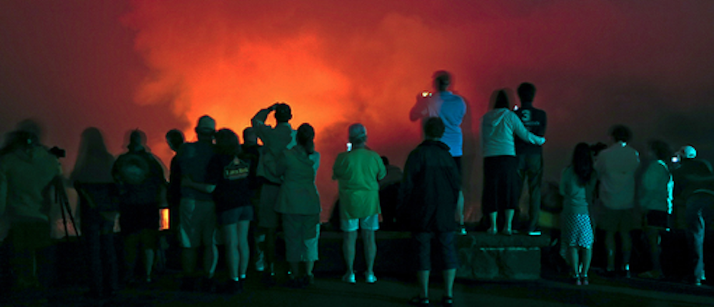
Over the past few weeks we’ve seen increasingly spectacular images reported in the news of the ongoing eruption at Kilauea volcano, on the Pacific island of Hawai’i.

These have been tempered by reports of growing destruction, with houses and infrastructure bulldozed, buried or burned by lava flows.


Read more:
Trouble in paradise: eruptions from Kīlauea volcano place the Hawaiian island on red alert


Yet Kilauea is one of the world’s most active volcanoes, and has been erupting continually since 1983. So what has triggered this sudden change in activity, threatening homes and livelihoods? The answer relates to what is happening beneath the volcano.

Kilauea volcano

Activity at Kilauea is driven by the buoyant upwelling of a plume of hot mantle, which provides the heat to generate magma beneath the volcano. This magma has the potential to erupt from several different locations, or vents, on the volcano.

Click on the three blue markers to reveal more.
Google Maps/The Conversation

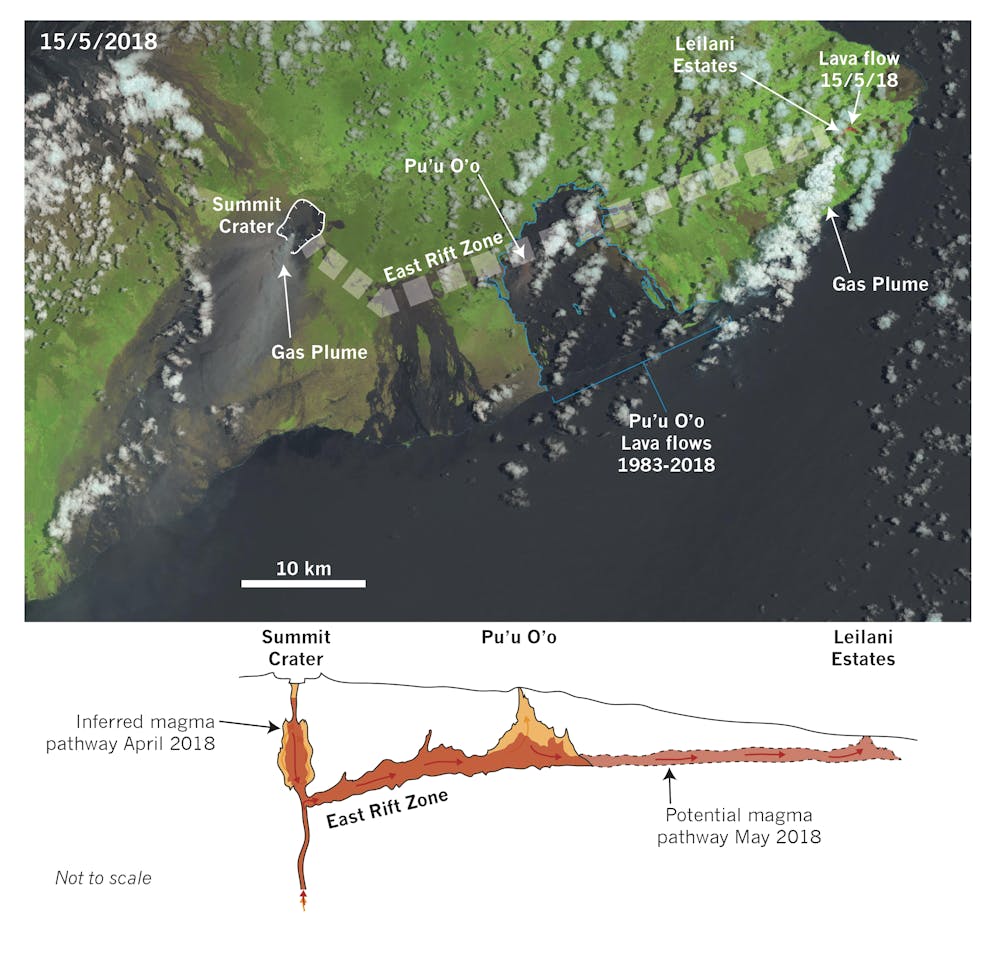
Typically, the crater at the summit of the volcano is where eruptions are expected to occur, but the geology of Kilauea is complex and a rift on the eastern side of the volcano also allows magma to erupt from its flanks.

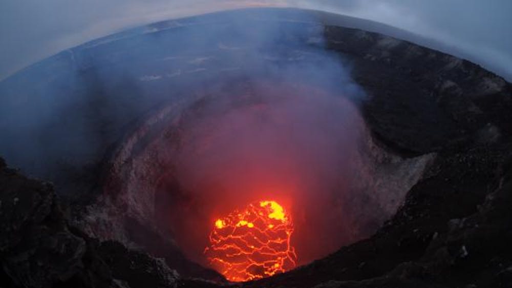
Over the past decade both the summit crater and a vent on the eastern rift, called Pu’u O’o, have been continually active. The summit crater has hosted a lava lake since March 2008.

Lava lakes are relatively rare features seen at only a handful of volcanoes around the world. The fact that they do not cool and solidify tells us that lava lakes are regularly replenished by fresh magma from below.

In contrast, Pu’u O’o, 18km east of the summit crater, has been pouring out lava flows since 1983. In the first 20 years of this eruption, 2.1km³ of lava flows were produced, equivalent in volume to 840,000 Olympic swimming pools. All of this tells us that Kilauea volcano regularly receives lots of magma to erupt.

Current eruptions

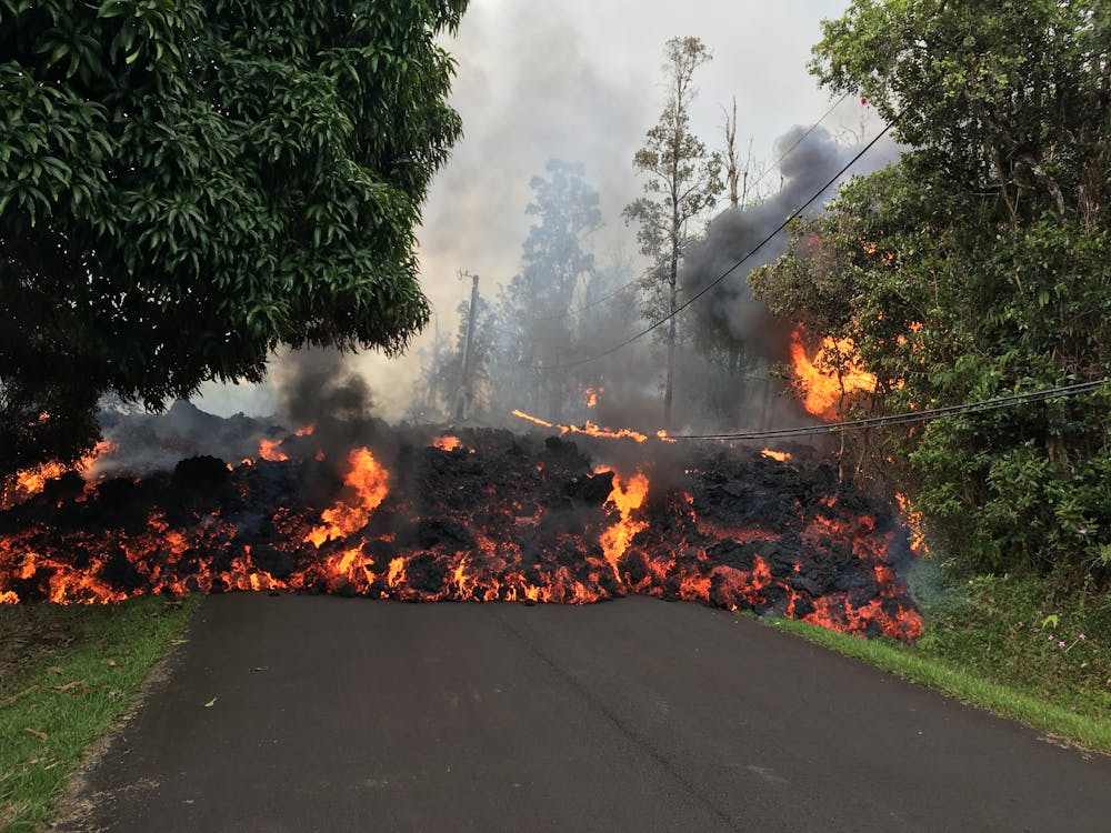
Over the past three weeks activity at Pu’u O’o has stopped, while a series of fissures has opened roughly 20km further east in a subdivision known as Leilani Estates.

This area was previously affected by lava flows in 1955.

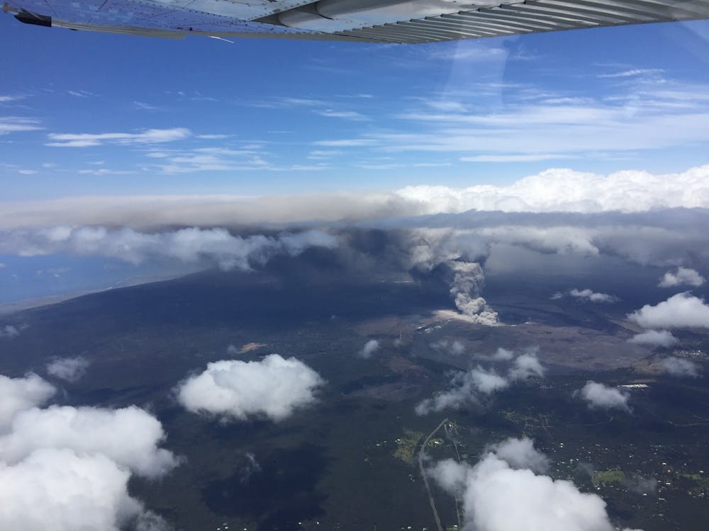
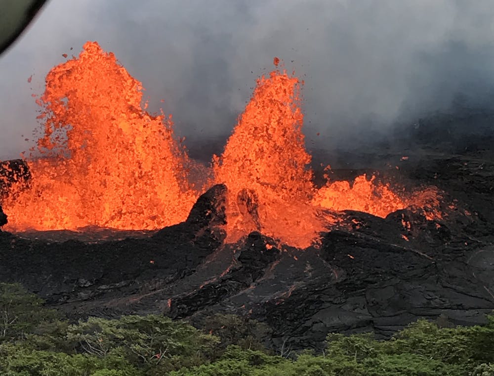
To date, 23 fissures have opened, starting off simply as cracks in the ground, with some developing into highly active vents from which significant lava flows are forming.

At the moment, the longest flows are about 6km long, having reached the ocean. This is a further cause for concern, as the lava reacts with seawater to form a corrosive mist.

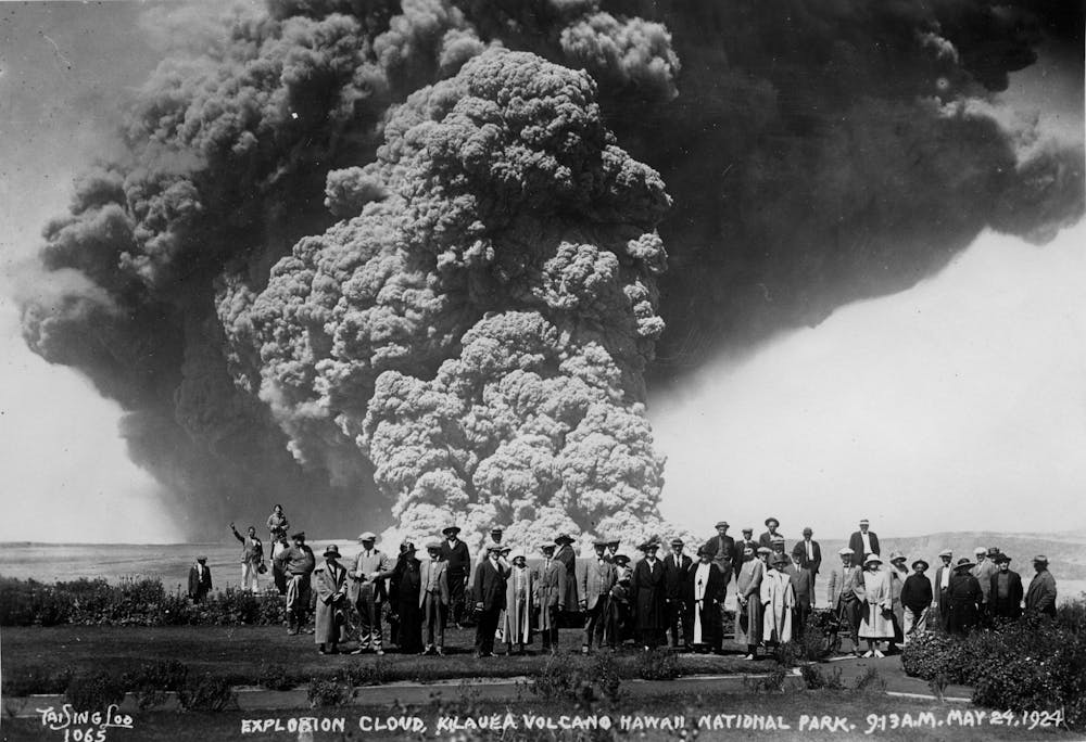
Meanwhile, at the summit of the volcano, the lava lake has drained from the crater, sparking fears of more explosive eruptions, as draining magma interacts with groundwater.

Satellite instruments and high-resolution GPS are being used to monitor changes in the shape of the volcano and have found that the summit region is deflating, while the lower east rift zone, where new fissures have opened in recent days, is inflating.

https://www.facebook.com/plugins/post.php?href=https%3A%2F%2Fwww.facebook.com%2FUSGSVolcanoes%2Fposts%2F2033901316638419&width=500

The magma reservoirs that feed eruptions on Kilauea can be imagined as balloons, which grow when they are filled and shrink when they are emptied. Deflation at the summit, combined with observations that the lava lake has drained (at a rate of up to 100m over two days!), suggest that the magma reservoir feeding the summit is emptying.

Where is the magma going? Observations of ground inflation around the newly opened fissures to the east indicate that the magma is being diverted down the east rift and accumulating and erupting there instead.

Exactly what has caused this rerouting of the magma is still not clear. A magnitude 6.9 earthquake occurred in the area on May 4 and this may have opened a new pathway for magma to erupt, influencing the geometry of the lower east rift zone.

A Landsat8 image (top) of Kilauea volcano taken on March 15, 2018. The relative location of the various vents are marked, and a red, glowing lava flow can just be seen in the north-east of the image. The graphic (bottom) shows an inferred magma pathway below the volcano.
NASA/Chris Firth, Author provided

Lessons for the future

By combining measurements from Kilauea of ground deformation, earthquake patterns and gas emissions during the current eruption, with observations of the lava that is erupted, volcanologists will be able to piece together a much clearer picture of what triggered this significant change in eruption over the past few weeks.

This knowledge will be crucial in planning for future eruptions, both at Kilauea and at other volcanoes.


Read more:
Lava in Hawai’i is reaching the ocean, creating new land but also corrosive acid mist


Eruptions from the flanks of a volcano can pose a much more significant hazard for the local population than those from a volcano’s summit, as many more people live in the areas that are directly affected.

This has been amply displayed over the past few weeks on Kilauea by the fissures opening in people’s gardens and lava flows destroying homes and infrastructure.

But Kilauea is not the only volcano to have flank eruptions. For example, lava flows famously emerged from the lower slopes of Mt Etna in 1669, destroying villages and partially surrounding the regional centre of Catania, on the east coast of Sicily, Italy.

The ConversationLessons learned from the current eruption of Kilauea can equally be applied to other volcanoes, like Etna, where more densely populated surroundings mean that the hazards posed by such an eruption would be even greater.

Lava fountains form fissure 22 on the lower east rift zone of Kīlauea volcano, in Hawai’i.
USGS

Chris Firth, Lecturer in Geology, Macquarie University

This article was originally published on The Conversation. Read the original article.

Trouble in paradise: eruptions from Kīlauea volcano place the Hawaiian island on red alert


Rebecca Carey, University of Tasmania

A code red alert level for aviation has been issued this week on Hawai’i’s big island, as Kīlauea volcano continues its explosive activity at the summit.

The Hawaiian Volcano Observatory’s warning for Kīlauea said:

At any time, activity may become more explosive, increasing the intensity of ash production and producing ballistic projectiles near the vent.

But Kīlauea has erupted before, and just as today its violent activity attracted the crowds. The challenge for authorities is to balance that curiosity with the safety of people on the island.

The observatory warning said there were reports of an ash cloud reaching heights of up to 3.5km above sea level. Ashfall and vog (volcanic air pollution) have been reported almost 29km downwind of the summit.


Read more:
Curious Kids: why doesn’t lava melt the side of the volcano?


There were also reports of new fissures erupting lava into new areas furthering the extent of the damage.

A lava flow from one of the fissures moves on Makamae Street in Leilani Estates on May 6.
USGS

Respect for Kīlauea

Kīlauea is a majestic and beautiful volcano. Native Hawaiians and Hawai’i residents who live on her flanks speak of her beauty with a healthy dose of respect and awareness of the constant threat of eruptive activity and destruction.

Kīlauea’s eruptive activity this year began in early May in residential areas on its east flank, about 35km from the summit.

A new fissure erupting from Luana Street, Leilani Estates subdivision on Kilauea Volcano’s lower East Rift Zone near Pahoa, Hawai’i, May 5, 2018.
USGS

The eruptive activity has captivated us for days. Spectacular fountains and rivers of lava have been emanating from volcanic vents, together with the tragic destruction of property and livelihoods.

This devastation led to President Donald Trump’s declaration of a “major disaster” on the island.

Crucially, residents are safe, but those who have visited Hawai’i or with similar experiences of destructive natural hazard events will be sad to see pictures of this devastation.

At the same time, and away from the current eruption on the flank of Kīlauea, another crisis is unfolding at the volcano’s summit. Kīlauea Volcano hosts the Hawaii Volcanoes National Park at its summit, which is now closed to all visitors because of the hazard.

It may seem odd that at a distance of more than 35km from the active spattering and lava effusion on the eastern flank of the volcano, volcanic hazards pose such a significant risk to warrant the closure.

But Kīlauea is up to its old tricks again, possibly replicating activity seen last in 1924 which led to a variety of violent and sporadic explosions, dispersing volcanic ejecta around the summit and killing one visitor.

A crowd of visitors view the eruption plume from the front of the Volcano House hotel. They were subsequently warned by Ruy H Finch, acting director of the Hawaiian Volcano Observatory, that it was unwise to remain there.
USGS

The decision to close access to the summit is driven by current monitoring data, and crucial past experience and knowledge of Kīlauea’s violent behaviour.

Over the past week the mesmerising convecting lava lake that has resided at the summit for a decade is no longer. Magma has evacuated to depths greater than 285m into the deeper magma plumbing system.

The summit lava lake has dropped significantly over the past few days, and on May 6 was roughly 220m below the crater rim.
USGS

The last time that happened – in 1924 – it explosively interacted with groundwater at depth, producing violent, sporadic eruptions and a visitor fatality.

This block was thrown out during an explosion at Halema‘uma‘u crater on Kīlauea on May 18, 1924, and landed about 600 meters from today’s rim.
USGS/HVO photo courtesy of Bishop Museum

Volcanic hazards at Kīlauea and the ‘ash problem’

Hazards from violent explosive activity at Kīlauea’s summit are substantial. Magma and water interactions are highly intense and violent – think hot oil in a frying pan mixing with cold water.

Eruptions are likely to have very little or no warning, and the “how big” and “how long” are impossible to predict.

Civil Air Patrol flight CAP20 reported plume tops at about 2.9km with the dispersed plume rising as high as 3.5km.
USGS

Residents on the fringe of the national park are not in life-threatening hazardous conditions. But they are susceptible to the annoying “ash problem” where ash accumulation on electricity infrastructure interrupts supply, contaminates water, causes health hazards such as throat and lung irritation, and damages crops.

This will have complex social, health and economic impacts, further devastating communities if the summit activity does begin and is long-lived.

Society’s fascination of volcanic phenomena and the curiosity-driven need of people to know more, see more and experience more will make the safe management of the millions of tourists each year in the Hawaii Volcanoes National Park a significant challenge.

Nearly 50km of bumper-to-bumper traffic to view the 1959 eruption of Kilauea testifies to the impending management issues.

Bumper to bumper traffic on the way to see the eruption in 1959.
YouTube/Centre for Study of Active Volcanoes/Screengrab

Exclusion and access will be an important and potentially long-lived management issue as the geological rock record at the summit tells a story of violent, centuries-long explosive activity.

Reading the rock record

Kīlauea is not a gentle giant of a volcano. It has a long-lived and violent explosive history as determined from detailed geological investigations of volcanic rocks and ash layers in the rock record.

The last period of violent explosive activity was between the years 1500 and 1800, when magma frequently interacted with the groundwater table deep within the volcano.

During those three centuries of activity, Kīlauea’s summit produced around 10km high columns and umbrella clouds of volcanic ash, short-lived violent explosions and ballistic ejecta, and ground-hugging high-velocity currents called pyroclastic density currents, which destroyed everything in their path.

This period is not without observation. Native Hawaiians were within the summit area and in 1790 at least 80 Hawaiian warriors were killed in a devastating hot, high velocity explosion that seared their lungs.


Read more:
Lava, ash flows, mudslides and nasty gases: Good reasons to respect volcanoes


Back to basics: the geological rock record as a prediction tool

Kīlauea is one of Earth’s most well studied volcanoes. It has been the site of an active volcano observatory since 1912, and current monitoring technologies are state-of-the-art.

Always a crowd pleaser: Visitors observing the Halemaʻumaʻu eruption in Hawaii Volcanoes National Park in 2017.
Bruce Houghton, University of Hawaii at Manoa, US, Author provided

Volcanic behaviour is by its nature complex. Prediction of the exact when, duration and how big is riddled with uncertainty despite sophisticated monitoring technologies.

The ConversationAs such, disaster management challenges are numerous, but observational records in 1924 and the geological rock record have certainly provided early warning of the timing, type and duration of possible violent activity at the summit, and therefore the protection of people within the national park.

Rebecca Carey, Senior Lecturer in Earth Sciences, University of Tasmania

This article was originally published on The Conversation. Read the original article.